About Coordinates
RSLog uses coordinates to insert the project or borehole locations on a map and to provide GIS capabilities across the application. The coordinate reference systems that are supported by RSLog are listed below. Please note that coordinate system is selected at the project level when you create a new project:
- Geographic (WGS 84): This coordinate system uses Latitude (specifies the north–south position of a point on the surface of the Earth) and Longitude (specifies the east-west position of a point on the surface of the Earth), both entered as decimal numbers. In RSLog when you place a point (borehole or project location) on the map, RSLog automatically saves the Latitude and Longitude of that point in the database. Alternatively, you can enter the coordinates manually.
- Projected: A Projected coordinate system is a type of spatial reference system that represents locations on Earth using Cartesian coordinates (x, y or Easting / Northing) on a planar surface created by a particular map projection. Thousands of projected coordinate systems have been specified for various purposes in various regions (e.g State Plane Coordinate System, British National Grid, etc). Projected coordinate system is used in international standards such as the EPSG (European Petroleum Survey Group) and ISO 19111 and in most geographic information system software.
- Universal Transverse Mercator (UTM): UTM is a map projection system for assigning coordinates to locations on the surface of the Earth. In order to use UTM coordinates in RSLog, in addition to Easting / Northing (m) you need to specify the UTM Zone of the project site. This enables RSLog to translate the UTM coordinates to Geographic coordinates which is required by the maps. The UTM Zone of a project is specified at the project level when creating a project, with the default UTM Zone set on the Settings page. In addition, RSLog can automatically detect your UTM Zone if user has enabled Location Services (see below).
- Local: In this system, user enters X and Y of the point relative to a local datum. Since this datum is unknown to RSLog, the program will not be able to utilize any GIS features (maps, cross section, etc.) for these projects.
For projects with UTM or Projected coordinate reference systems, RSLog internally converts the coordinates to Geographic coordinates (i.e. Latitude and Longitude) so that the points could be shown on a map.
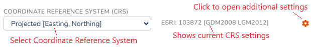
The coordinate system is selected from the Coordinate Reference System (CRS) dropdown on the project edit page. For Projected coordinate system, additional settings are available by clicking the  button next to the dropdown.
Using Geographic Coordinates
If project's coordinate system is set to Geographic (WGS 84), the coordinates are entered as a decimal number for Latitude and Longitude of that specific point. In this case, RSLog uses these coordinates for locating the boreholes and projects on the maps, GIS page and on Cross-Section Designer page.
Using Projected Coordinates
If project's coordinate system is set to Projected, the coordinates are entered as decimal values for Easting and Northing in feet or metres depending on the coordinates system selected. Behind the scene, RSLog converts these coordinates to Geographic coordinates (i.e. Latitude and Longitude).
After selecting the Projected coordinate system for your project, click the button next to the dropdown. This will open the dialog shown below:
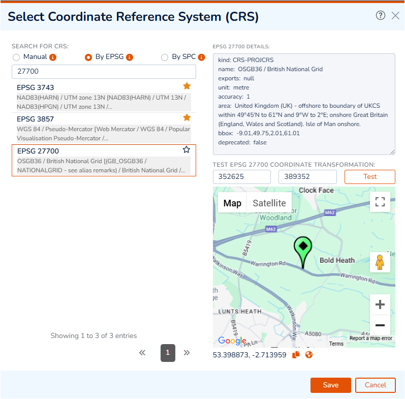
On this page you can search for a Projected coordinate system by selecting from the following options. If you are not sure about the CRS system used in your project, consult with the project surveyor:
- By EPSG: allows searching for a CRS code and/or a country or city name though all EPSG standard codes. EPSG is an organization that maintains a geodetic parameter database with standard codes (EPSG codes) for coordinate systems, datums, spheroids, and units. Every coordinate system gets assigned a unique number.
- By SPC: allows searching for a CRS code and/or a state or county name though all SPC standard FIPS codes. The State Plane Coordinate System (SPCS), which is only used in the United States, is a plane coordinate system in which each individual state has between one to six zones. The SPCS covers 120 different zones that generally follow county boundaries. Each zone is identified by a unique FIPS code.
- Manual: allows searching for a CRS code that is not covered by EPSG or SPC datasets (e.g. ESRI codes).
After searching, select your desired coordinate system from the list. This shows the details of the selected CRS on the top-right portion of the page.
Testing Coordinate Conversion
The test section of this dialog can be used to verify that the correct CRS code is selected. To test, please follow these steps:
- enter the coordinates for one of your boreholes in Easting and Northing textboxes,
- click Test button,
- check the location shown on the map and make sure it is shown at the right location,
- use the Copy button below the map to copy the geographic coordinates of the test point,
- use the Globe button below the map to open test point on Google map (opens a new tab).
Click Save button to close this dialog.
Using UTM Coordinates
If project's coordinates system is set to UTM, the coordinates are entered as decimal numbers for Easting and Northing (always in metres). Behind the scene, RSLog converts these coordinates to Geographic coordinates (i.e. Latitude and Longitude) for placing the boreholes and projects on the maps, GIS page and on Cross-Section Designer page.
For a UTM coordinates system user should specify the UTM Zones, comprising a letter and a number; For example U 10 is used as the UTM Zone for projects located in Vancouver, BC, Canada.
Using Local Coordinates
In a Local coordinates system, project and borehole coordinates are entered as decimal numbers for Easting, Northing (X, Y). The units of coordinates come from the unit system selected for the project. We do not recommend using this coordinates system mainly due to the fact that the coordinates could not be translated to Geographic coordinates and therefore boreholes cannot be shown on the maps, GIS page and Cross-Section Designer.
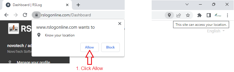
Location Services
A location-based service is a general term denoting software services which use geographic data and information to provide services or information to users. After logging in to your RSLog account the browser will ask you for permission to activate Location Services (see below). This allows RSLog to use your location when placing a borehole on a map or for automatic calculation of your UTM Zone.
If you change your mind, you can always remove Location Services from the settings page of your browser.