GIS System
Once a project or test hole is added to your RSLog account, if it has a valid coordinates it will be shown on the GIS map. This map allows you to search for a specific geographic location, find your projects, and filter projects.
To access this page:
- Go to the left-hand navigation menu and select GIS Map. The page should appear as follows:
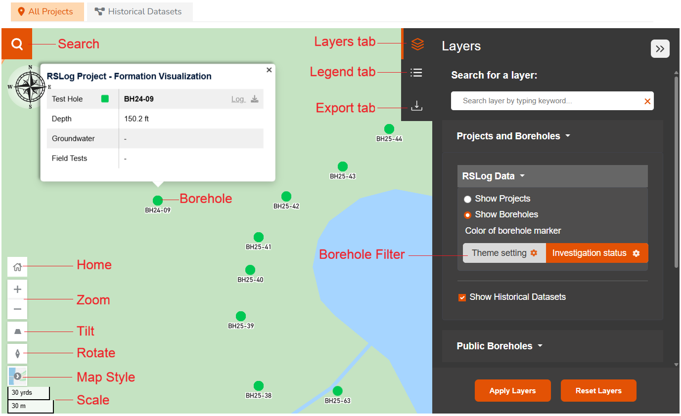
Home
The Home button takes the map to the default location specified on your Company Account page: if City is specified on this page, the GIS map will zoom to the city, otherwise it will zoom to the State.
Search Bar
The Search bar allows you to search for a location or a project. Start typing in the search area and select the desired option from the list.
Map Controls
Use map controls to zoom, tilt and rotate the map. The map style offers the following choices:
- Road: shows the conventional map with roads and road labels.
- Satellite: shows the satellite imagery without road labels.
- Hybrid: shows the satellite imagery with road labels.
- Night: similar to the Road view but colors are in night mode.
- Terra: shows the conventional map with roads, labels and terrain shading.
Layers tab
Located on the top-right of the map, this tab allows you to add/remove various GIS layers to the map. Select the layers you would like to see, and click on Apply Layers button. The following options are available:
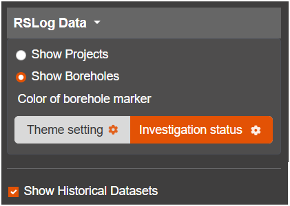
RSLog Data
Choose to show the locations of projects or boreholes on the GIS map. The following options are available for the color of the borehole markers:
- Theme Settings: markers icons and their colors come from the Settings → Global Settings page,
- Investigation Status: marker icons come from the Settings → Global Settings page, but the colors of markers are based on your project's 'data template' settings for borehole investigation status (Settings → Data Entry → Quality Management tab).
In addition, you can select to show/hide the locations of your Historical Data (added to the GIS map through the Historical Dataset tab) on the map.
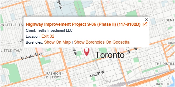
Project Callout
When the locations of your RSLog projects are shown on the map, hover on the project map marker to access more options from the callout:
- Show On Map: this will show the locations of all boreholes of the subject project on the map. To hide click on Remove from the Map link.
- Send To Geosetta: this feature will send the locations of all boreholes of the project to Geosetta website.
Borehole Callout
Click on a borehole marker to view general borehole data including access to the most recent borehole log.
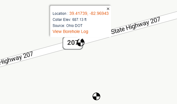
Public Boreholes Dataset
The availability of public borehole data is mainly dependent on the local authorities sharing data on their website or with the other organizations.
- Canada: If you are located in Canada, you can choose from groundwater data and public boreholes.
- United States: This dataset is provided to Rocscience by Geosetta website; The data collected from various Departments of Transportation in the US. Currently this dataset exceeds 500,000 boreholes.
- United Kingdom: this dataset comprises soil samples, water wells, geophysical data and public boreholes.
If you would like to include the public data for your region, please contact us with details about how to access this data. Due to the large number of public boreholes, they are shown with light-red/pink map clusters. As you zoom in (or click on a cluster), the clusters break up into smaller clusters until the map markers for public boreholes become visible. Hover on the borehole and click on the View Borehole Log link. This will take you to the Geosetta website to generate the boring log.
Geological Maps
The geological maps added to the GIS Map are generally sourced from US Geological Survey (USGS) or the One Geology website. If you would like to add more geological map to RSLog, please contact us with the details about the source of the map.
Uploaded Files
Use this feature to upload GIS files such as Google Earth (KML, KMZ), GeoJSON, GPX, WKT, Shapefiles (as .zip) to the GIS map.
Link to External OGC Maps
Use this feature to link external OGC maps (WMS or WMTS formats) to the GIS map. These could be geology maps, public boreholes, water wells, etc.
Legend tab
The legend tab shows the legend of the geology map (if loaded in to the map), and the list of various map markers used (e.g. RSLog project, public borehole).
Export tab
This page allows you to export the current view of the map to the following formats:
- Google Earth (*.KML)
- GeoJSON (*.JSON)
- GPS Exchange (*.GPX)
- Spatial CSV (*.CSV)
- Well-known Text (*.WKT)
- Geography Markup Language (*.GML)
- Image (*.PNG)
Historical Datasets
Use this feature to import the locations of your historical data (i.e. those before you switch to RSLog) to the GIS map. This data should be uploaded from a CSV files and will be shown on the map with a different map marker. Once datasets are imported you can:
- Delete or edit historical data points (i.e. a project or borehole),
- Add data points manually,
- Import more data points from a CSV file with the following columns:
- Project / Borehole Name: depending on whether the file contains project locations or borehole locations, this column carries the name or title of that data point.
- Project No.: refers to the project identifier for that data point.
- Client Name: refers to the name or title of the project.
- Civic Address: if geographic coordinates of the data point is unavailable, RSLog uses geocoding to convert address to geographic coordinates.
- Latitude: used for placing the data point on the map.
- Longitude: used for placing the data point on the map.
- Reference URL: this takes user to a specific web page when that data point is selected on the GIS map.