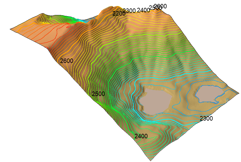
Rocscience International Conference 2025 is going to take place in Sydney, Australia Read more

Search Results

Topographic Lines

The Topographic Lines option allows users to project topographic lines and elevation data directly on the their 3D model. The topographic lines turn the model into a topographical map and can serve as a visual aid to place slope-dependent elements (such as seeders and barriers).

  • Select Annotate > Topographic Lines or click on the Topographic Lines topographic lines icon icon in the toolbar to turn on this feature.

Using the Properties pane, users can adjust various aspects of the topographic lines including:

  • Line Spacing
  • Show Minor Lines - yes/no
  • Offset
  • Number of Minor Lines
  • Show Labels - yes/no
  • Show Label Background - yes/no
  • Show Label Color - yes/no
  • Show Colors - yes/no
  • Show Colors Legend - yes/no

Contour Colors

Checking the Show Colors option in the Properties pane will turn on the contour color map option to assist users in better visualizing their elevation data.

RocFall3: Model with topographic lines

Rocscience logo, click here to return to the homepage Portal Account Portal Account Log In Log Out Home Shopping Cart icon Click here to search our site Click here to close Learning Tech Support Documentation Info Chevron Delete Back to Top View More" Previous Next PDF File Calendar Location Language Fees Video Click here to visit Rocscience's LinkedIn page Click here to visit Rocscience's YouTube page Click here to visit Rocscience's X page Click here to visit Rocscience's Facebook page Click here to visit Rocscience's Instagram page Click here to visit Rocscience's Reddit page Bookmark Network Scroll down for more Checkmark Download Print Back to top Single User Multiple Users RSLog RocFall3 CPillar Dips EX3 RocFall RocPlane RocSlope3 RocSupport RocTopple RS2 RS3 RSData RSPile Settle3 Slide2 Slide3 SWedge UnWedge RocTunnel RocSlope2 Commercial License Education License Trial License Shop safe & secure Money-back guarantee