Geo-referencing of the 3D Model
The 3D model is transformed into a global co-ordinate system by using the known co-ordinates of externally surveyed Ground Control Points. It requires following points:
- toe position of the Left Range Pole
- toe position of the Right Range Pole
- toe position of the Left Delimiter
- toe position of the Right Delimiter
The Control Points have to be surveyed accurately either by total station measurement or by accurate GPS. Accuracy of the final results is directly related to the accuracy of the Ground Control Points. The accuracy of the co-ordinates of the Ground Control Points should be in the one centimetre range or better.
Refer to Referencing | Ground Control Points for detailed information about referencing with Ground Control Points
The co-ordinates (E/N/H or latitude/longitude/altitude) can be loaded from a “.txt” file or other text based files (e.g. “.csv”, “.prt”, “.dat”). The format has to be defined correctly during the import process. Examples:
- Point – Comma
XX.XXX,YY.YYY,ZZ.ZZZ - Comma – Semicolon
XX,XXX;YY,YYY;ZZ,ZZZ - Point – Space
XX.XXX YY.YYY ZZ.ZZZ - Co-ordinates:
Easting / Northing / Elevation
9453674.75 456235.21 248.45
9452978.18 456576.89 223.15
9458763.65 456832.76 287.83 - Point name and co-ordinates:
GCP_Name / Easting / Northing / Elevation
GCP1 9453674.75 456235.21 248.45
GCP2 9452978.18 456576.89 223.15
GCP3 9458763.65 456832.76 287.83
Standard operating procedure
- Select the icon “Load Ground Control Points”
 from the toolbar
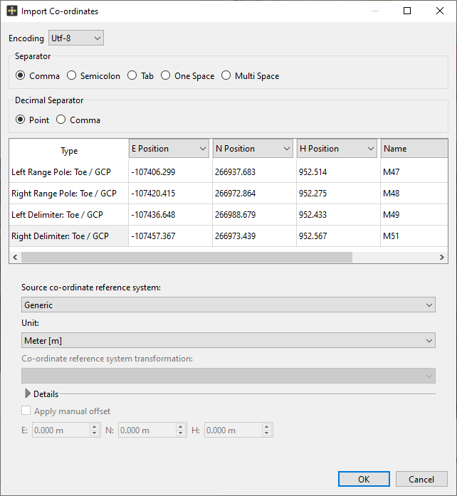
 - A dialog window () appears requiring following inputs:
- Character encoding
- Used separator
- Data classification (E/N/H and name or latitude/longitude/altitude and name)
- Select the Source co-ordinate reference system Generic from the pull-down menu
- Select the unit from the pull-down menu for undefined source co-ordinate reference systems. Available units are (millimeter [mm], meter [m], inch [in], international foot [ft], US survey foot [ft])
- Click the “OK” button to import the co-ordinates