From the Aftermath to the Analysis: Reconstructing Rockfalls in RocFall3 using Crowdsourced Imagery
- Beverly Yang, Geomechanics Specialist at Rocscience
Back-analyzing a rockfall requires more than identifying where a block came to rest. Engineers need to understand where it detached, how it moved, where it impacted and how the slope’s geometry influenced its trajectory.
Traditionally, this involves collecting site-specific information through field investigation and developing a model that reproduces the observed event. However, access to the site may be difficult or delayed, while debris removal, restoration work and other changes can quickly compromise the evidence needed for analysis.
Could publicly available imagery provide an efficient alternative or supplement to field data? And could detailed 3D terrain models improve the way rockfall trajectories are back-analyzed?
A 2025 study by Pavlos Asteriou, Dimitrios Zekkos and John Manousakis explored these questions through two rockfall incidents in Greece. The researchers used crowdsourced UAV footage and using the resulting 3D terrain models for trajectory back-analysis in RocFall3.
The approach combines two key advantages. Publicly available imagery can provide useful site information without relying solely on a dedicated field visit, while 3D terrain reconstruction captures slope geometry that simplified 2D profiles cannot fully represent. By incorporating this geometry into the trajectory analysis, RocFall3 can account for lateral variations in the terrain and reduce the modelling assumptions and trial-and-error attempts needed to match observed rockfall behaviour.
The researchers investigated two rockfall incidents in Greece. At Agia Fotia, UAV imagery from before and after the event enabled them to compare the terrain and estimate the volume of detached material. At Kakia Skala, only post-event footage was available, requiring the researchers to draw on other evidence to interpret the incident.
Using Structure-from-Motion (SfM) photogrammetry, the researchers reconstructed the sites in 3D and conducted trajectory back-analysis in RocFall3. Together, the case studies demonstrate how crowdsourced imagery and 3D rockfall modelling can support remote incident investigation, even when conventional field data are limited.
From Online Footage to a 3D Model
The first challenge was finding usable imagery.
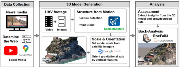
UAV footage published online following a rockfall incident may contain information about slope morphology, detachment zones, block dimensions, deposition areas and potential trajectory paths. Although such footage is not collected as part of a conventional engineering survey, it can provide a valuable record of the site shortly before or after an event.
The researchers extracted individual frames from publicly available UAV videos and processed them using Structure-from-Motion photogrammetry. Overlapping images were used to reconstruct the terrain as a 3D point cloud and digital surface model.
Because the original videos did not include standard survey information, the reconstructed models also had to be scaled and oriented. Measurable features from available mapping and imagery were used to establish scale and define the spatial context of the models.
Once the terrain and incident evidence had been reconstructed, the researchers could move from documenting the event to investigating possible rockfall behaviour through 3D trajectory back-analysis in RocFall3.
Agia Fotia: Reconstructing the Rockfall
The first case study examined a rockfall incident at Agia Fotia on the southern coast of Crete.
The detachment area consisted of thick-bedded conglomerate overlying coarse sands and marls, with stratification dipping towards the slope. Weathering and wave action had contributed to the formation of marginally stable, overhanging blocks. Heavy rainfall preceding the incident may also have influenced the failure.
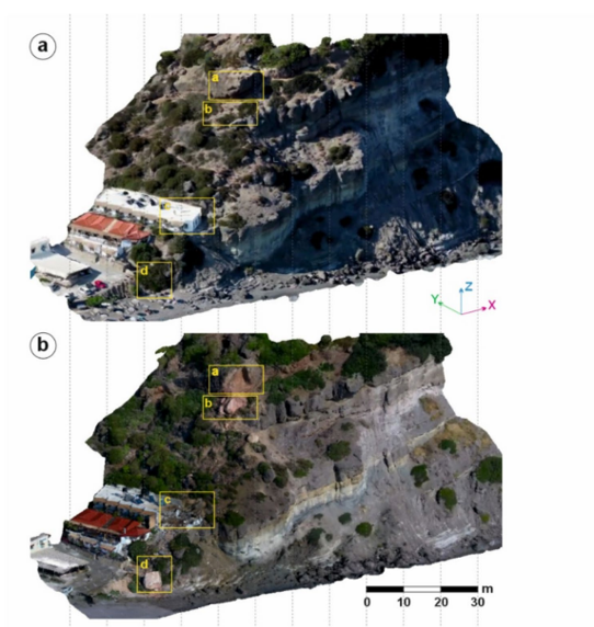
Two UAV videos provided imagery of the site before and after the event. The first was a tourism video recorded approximately 18 months before the rockfall, while the second was a news drone video captured one day after the incident.
The researchers extracted 468 frames for the pre-event model and 338 frames for the post-event model. The average ground resolutions were approximately 3 cm/pixel and 2 cm/pixel, respectively.
From Terrain Reconstruction to Trajectory Analysis
The two point clouds were initially aligned with an RMS 3D error of 5.2 cm. After areas affected by moving objects and detached material were masked, the alignment improved to approximately 1 cm.
The comparison indicated that approximately 145 m³ of material had detached from the slope. It also enabled the researchers to examine the final position of the main terminal fragment, estimated to have a volume of approximately 65 m³ and a mass of 162.5 tonnes, based on a rock density of 2,500 kg/m³.
The fragment travelled approximately 52 m in 3D distance and descended approximately 35 m before reaching the beach. The mean slope gradient along the rockfall path was approximately 42°.
Before conducting the trajectory analysis, the reconstructed surface was prepared for simulation. Boulders below the detachment area and tall vegetation along potential trajectory paths were manually removed because surface roughness can influence calculated trajectories. The resulting gaps were filled using smooth, interpolated triangles to create a continuous ground surface.
The analysis used RocFall3’s lumped mass approach. Coefficients of restitution and friction were estimated from published literature and previous experience in similar geological environments. Since the exact initial release direction could not be established from the available evidence, the researchers applied an angular variation of ±30° from the slope’s dip direction and simulated 100 blocks.
The objective was to identify simulated trajectories in RocFall3 that matched the behaviour of the rockfall incident.
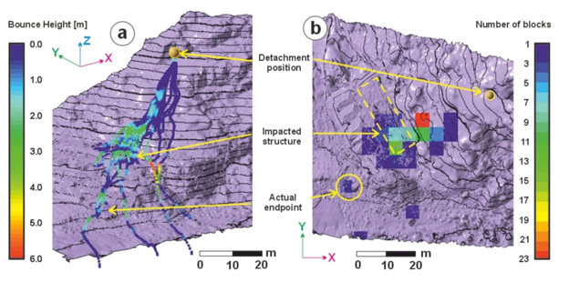
The simulation produced substantial lateral dispersion, calculated at 64.2%. The researchers associated this behaviour in part with the site’s convex, rounded topography, which encouraged trajectories to spread laterally rather than remain within a single vertical profile.
The trajectory that most closely matched the available physical evidence reproduced the sliding marks on the upper section of the slope, became airborne near the hotel and reached an endpoint close to the observed final position.
The simulation also provided an estimate of the block’s impact behaviour. The calculated trajectory showed the block becoming airborne immediately before reaching the hotel, with kinetic energy exceeding 16,500 kJ at impact.
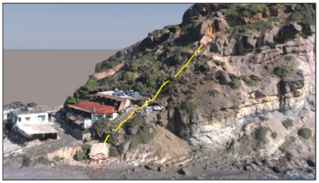
The value of the analysis extended beyond reconstructing the event visually. The 3D terrain model provided a spatial record of the incident, while the trajectory analysis allowed the researchers to compare possible rockfall behaviour with the evidence preserved at the site.
Kakia Skala: When Only the Aftermath Remains
The second case study presented a different set of constraints.
Kakia Skala is a steep slope on Mount Kavallaris in Attica, above the Athens–Corinth highway. The slope consists of massive and thick-bedded limestone affected by weathering, karstic erosion and tectonic discontinuities.
During the incident, blocks detached approximately 150 m above the road and travelled down a slope with a mean gradient of approximately 65°.
Unlike Agia Fotia, no pre-event UAV footage was publicly available. The researchers instead used high-definition UAV footage released by the highway operator one day after the incident.
From this footage, they extracted 366 frames covering approximately 0.4 km², with an average ground resolution of approximately 5 cm/pixel.
Although the absence of a pre-event model limited the available comparisons, the imagery still provided information about the post-event terrain and the interaction between the rockfall and existing protective structures.
Approximately 5 m³ of debris had reached the road, with the largest block measuring approximately 1 m³. Two barriers intercepted the trajectories of some of the rockfalls, resulting in reduced kinetic energy of blocks impacting the highway.
Investigating Rockfall–Barrier Interaction
The researchers recreated the relevant conditions in RocFall3. The barriers were represented using an approximate height of 2.5 m, while the analysis used a 1 m³ block with an assumed mass of 2,500 kg. As in the Agia Fotia case, 100 blocks were released with an initial direction distributed within ±30° of the slope dip direction.
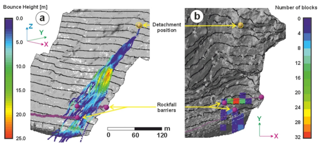
The simulated trajectories provided a basis for investigating the observed interaction between the rockfall and the protective structures.
The calculated impact energies reached approximately 900 kJ at the upper barrier and 740 kJ at the lower barrier, exceeding the assumed barrier capacity of 250 kJ used in the analysis. Approximately 20% of the simulated blocks reached highway level, while other blocks were intercepted by the barriers or remained within the modelled slope.
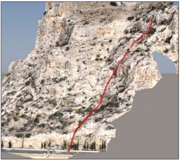
The closest matching simulated trajectory in RocFall3 corresponded closely with the observed deposition location of the largest block at road level.
The RocFall3 model produced a lateral dispersion of 28.8%, further illustrating how the three-dimensional terrain influenced the spatial distribution of the trajectories.
The Value of 3D Rockfall Back-Analysis
The two case studies demonstrate how crowdsourced imagery and 3D modelling can support rockfall investigations even when the available evidence differs. At Agia Fotia, pre- and post-event imagery enabled the researchers to compare the terrain and estimate the volume of detached material. At Kakia Skala, post-event footage supported trajectory back-analysis and an investigation of rockfall interaction with existing barriers, despite the lack of a pre-event UAV model.
The study also highlights the value of accounting for detailed 3D terrain geometry in rockfall back-analysis. Using RocFall3, the researchers reported fewer modelling assumptions and less trial-and-error effort than in previous 2D back-analyses discussed in the paper. Unlike a simplified 2D profile, a 3D model captures lateral variations in slope geometry that can redirect blocks, influence their trajectories and affect where they deposit or encounter protective structures. The simulated lateral dispersion was approximately 64.2% at Agia Fotia and 28.8% at Kakia Skala, illustrating the different trajectory distributions and endpoint locations at the two sites.
Crowdsourced imagery adds another practical advantage. Footage captured close to an incident can preserve information that becomes harder to recover as debris is cleared, restoration begins or site conditions change. Processed using Structure-from-Motion photogrammetry, this imagery can provide a 3D terrain model for trajectory analysis in RocFall3, offering an additional source of evidence when direct site access is difficult or conventional field data are limited.
The approach does not eliminate the need for engineering judgement or replace a dedicated site investigation. Incomplete footage, image quality, georeferencing and the absence of pre-event imagery can limit what can be established. Results also depend on the reconstructed terrain and assumptions about block properties and release conditions.
Nevertheless, the study demonstrates how combining publicly available imagery with RocFall3 can help engineers investigate past rockfall behaviour while retaining the spatial context of the slope. By reducing the simplifications required in 2D back-analysis, this workflow provides a practical alternative or complement to conventional investigation methods when site evidence is limited.
Elevate Your Slope Hazard and Trajectory Analysis
Discover the power of 3D kinematic and dynamic modeling with RocFall3
Try RocFall3 for Free