Settle3 in Action: Revolutionizing Soft Ground Settlement at Izmir Harbour
Controlling settlement on soft, reclaimed ground is more than a technical hurdle: it’s often the deciding factor for project safety, performance, and profitability in geotechnical engineering. Both over-designed and under-designed ground improvement solutions risk wasting budget or compromising long-term stability.
In this article, we uncover how advanced 3D modelling with Settle3, combined with full-scale field testing, enabled accurate design validation and performance monitoring for Rammed Aggregate Piers® (RAPs) at a container stockyard in Izmir Harbour. This practical case study bridges the gap between predictive analysis and proven field outcomes – empowering engineers to achieve safer, more reliable, and cost-effective solutions.
Project Background
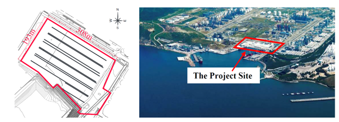
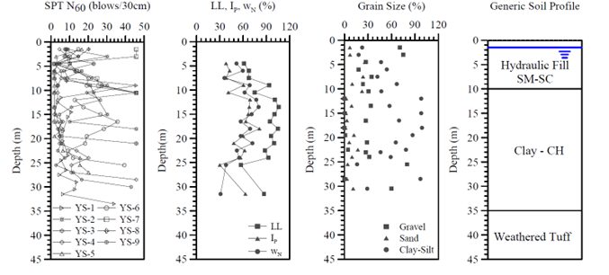
The project site was located within a private harbour in Izmir, Turkey and had been used as fill stockyard for the 10 months prior to construction. The site measured 193 m by 308 m, and ground investigations revealed the following subsurface conditions:
- Soil profile: Hydraulic fill (3–10 m) of gravelly silty/clayey sand above soft, high-plasticity clay (2–25 m), underlain by pyroclastic bedrock.
- Groundwater: Fluctuating between 0.6–2.3 m below surface.
Settlement Modelling of Untreated Ground
Two loading scenarios were considered in the analysis:
- Preloading effects from the random fill: The site was divided into two zones, with vertical stresses estimated at 54kPa and 108kPa using the Boussinesq method. The elastic modulus for the fill was taken as E = 7MPa.
- Consolidation and differential settlement: Evaluated using Settle 3 with a flexible foundation model, under a service foundation stress of 85kPa. The compression index ration (Cc/1+eo) = 0.22 and OCR = 1 were used for the soft clay layer
Seismic scenario modelled:
- Maximum acceleration (amax) = 0.4g.
- Moment magnitude (Mw) = 6.5.
Results
The combined elastic settlement of the hydraulic fill and consolidation of the underlying soft, high plasticity clay ranged from 40 to 60 cm – exceeding the tolerable limit for a container stockyard (200 mm in 2 years and 300 mm in 20 years).
The hydraulic fill posed a high liquefaction risk, with an average fine content of 15% under the modelled seismic conditions.
Ground Improvement Using Stiff Impact® Rammed Aggregate Piers
Based on the foundation stresses and soil profile, seven zones were defined, and Rammed Aggregate Piers (RAPs) were installed on a 1.5- to 2.0-meter square grid.
RAP Dimensions:
- Diameter: 50 cm.
- Length: 6 to 18 m.
The average measured stiffness from modulus tests was 50MN/m3, nearly twice the value assumed in the preliminary design (see Figure 3).
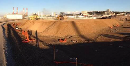
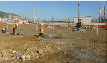
Full-Scale Field Load Test on Improved Ground
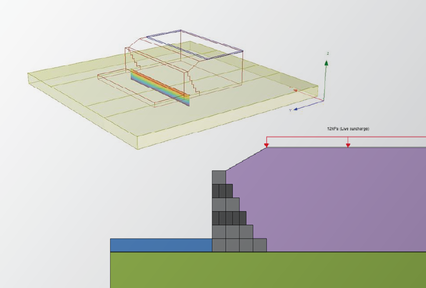
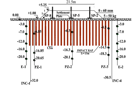
To verify the effectiveness of the design, a test embankment was constructed in a ‘worst-case’ zone identified from borehole data. The embankment had the following geometry:
- Side Slopes – 1V:1H
- Height – 4.25m (from +1.00m to +5.25m)
- Plan View Dimensions – 21.5m x 31.5m
- Combined thickness of fill and soft to firm clay – 24.8m to 26.2m
Vibrating wire piezometers, extensometers, and settlement plates were used to monitor total settlement and pore water pressures over 111 days.
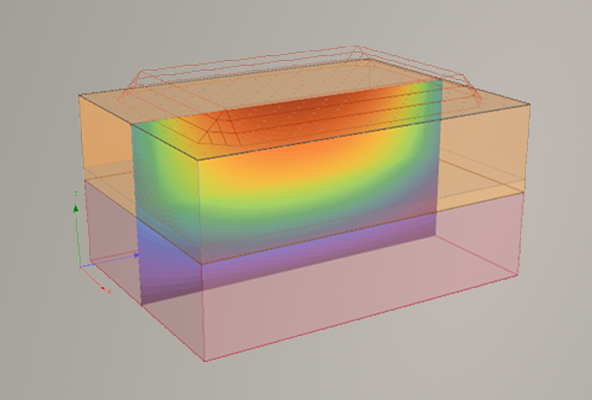
Settlement Modelling of Improved Ground in Settle3
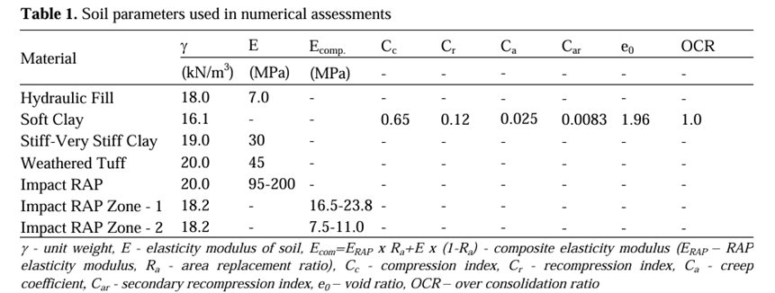
The geometry of the modelled embankment in Settle3 is shown in Figure 3. Table 1 summarizes the calculated modulus values and other input parameters for the Settle3 model.
Key Settle3 Features used:
- Flexible Foundation: Enabled realistic simulation of settlement behaviour over soft ground.
- Composite Modulus Approach: Modelled the RAP-improved zone using calculated stiffness values based on field modulus testing.
- User-defined 3D embankment geometry: The test embankment was modelled with the actual geometry.
Comparison of Full-Scale Field Data and Settle 3 Results
Figure 3 compares the field-measured settlements and 3D model predictions over time. The solid lines show settlements at surface monitoring points, dashed lines represent model-calculated settlements at the same locations, and solid lines with triangles indicate extensometer readings.
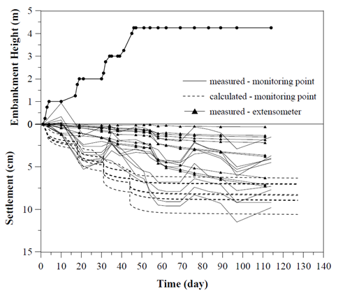
Key Findings
- Extensometers recorded smaller settlements than the geodetic monitoring points, as they were installed outside the test embankment area.
- Measured settlements at monitoring points were generally 30% lower than those predicted by the 3D model.
- Approximately two-thirds of the total settlement occurred in the untreated lower soil zone, while the remaining one-third was attributed to compression within the improved upper zone.
Conclusion
By integrating Settle 3’s advanced settlement modelling with comprehensive field monitoring, the Izmir Harbour team of engineers were able to accurately assess the effectiveness of the ground improvement design at the container stockyard. This case study underscores the power of flexible, data-driven modelling and the necessity of rigorous validation in demanding soil conditions.
By leveraging Settle3, engineers can confidently bridge the gap between prediction and real-world performance; achieving safe, reliable, and cost-effective outcomes even on the most challenging ground. For those seeking to de-risk high-value infrastructure projects, Settle3 transforms complex settlement challenges into proven, actionable solutions.
Source:
Performance Monitoring of Rammed Aggregate Piers: A Stockyard Case History Site” by Kurt Bal et al. (2018).
Experience Powerful Settlement Modelling With Settle3
Click here to request a free trial of Settle3 and explore its full capabilities.
Start Your Free Trial Today!