Using DIPS for Slope Stability Analysis in Jointed Sandstone: A Case Study from Markundi Hill, India
In the rugged landscapes of Sonbhadra’s Markundi Hill, instability in jointed rock slopes poses persistent threats to infrastructure and safety. Structurally controlled failures such as planar sliding, wedge sliding, and toppling are common failures in these conditions and often act as triggers for rockfall events.
In 2021, a groundbreaking study published in the Journal of the Geological Society of India (Volume 97, February 2021) examined the stability of rock slopes along State Highway 5 (SH-5) in Markundi Hill (Kumar & Pandey, 2021). At the core of this research was Rocscience’s DIPS software, which enabled a comprehensive stereographic and statistical analysis of the region’s geological structures.
DIPS is a graphical and statistical analysis software for interactive interpretation of orientation-based geological data, featuring tools for stereographic projection, kinematic analysis, and jointing assessment. By applying this digital, data-driven approach, engineers were able to identify critical zones of weakness – delivering actionable insights and enabling proactive measures to enhance slope stability.
Here’s how the combination of digital innovation, integrated analysis, and scientific rigor helped turn uncertainty into engineered confidence at Markundi Hill.
The Geological Setting
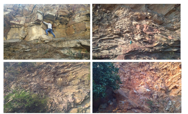
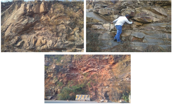
The study area is characterized by rugged terrain with highly jointed Vindhyan sandstone, which has been exposed due to road widening activities. The rock mass exhibits varying orientations of jointing and fracturing, leading to block instability and rockfalls, exacerbated by increased joint water pressures during the rainy season.
The Challenge
The research aimed to assess the stability of both the natural and artificial rock cut slopes at SH-5, identify potential failure modes, and propose mitigation strategies to prevent major incidents.
The Solution
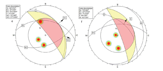
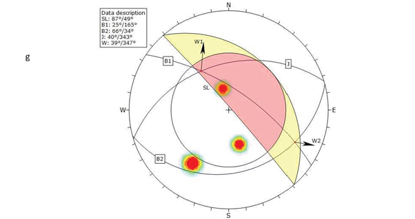
The researchers collected discontinuity data from seven locations around Markundi Hill, including orientation (dip and dip direction) of rock beds and joint sets, slope face orientation and friction angle of discontinuities. These parameters were input into DIPS to carry out a slope kinematic analysis for wedge sliding in which wedges are formed by the intersection of two planes.
Analysis Process
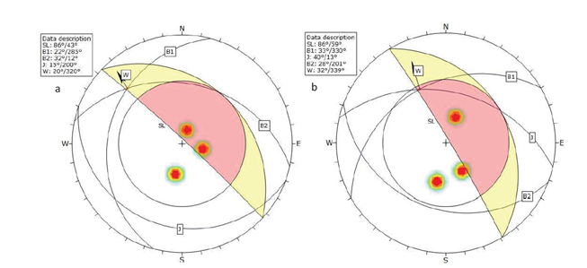
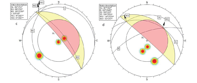
- Stereonet Plotting:
DIPS was used to plot the poles to planes of discontinuities and slope faces on stereonets, allowing visualization of their spherical vector relationships. - Failure Envelope Definition:
Based on the friction angle and slope dip and dip direction, failure envelopes were defined on the stereonets to highlight critical zones where wedge failure is possible. Wedge sliding can occur on both joints simultaneously along their line of intersection, or along either one of the joints. - Identification of Wedge Failures:
The software identified intersections of two joint sets forming wedge-shaped blocks. The plunge of the intersection line was compared with slope face orientation and friction angle to assess wedge failure potential. A kinematically valid wedge must daylight on the slope and will slide if the line of intersection plunge (if sliding on both joints), or the dip of plane (if sliding on a single joint) is steeper than the friction angle. - Critical Zone Highlighting:
DIPS automatically highlighted critical zones on the stereonet in distinct colors (e.g., yellow for sliding on a single joint, pink for sliding on both joints along the line of intersection), facilitating easy identification of vulnerable intersection orientations.
The Results
- The study revealed wedge failure as the dominant failure mode at most locations.
- The intersection lines of two joint sets-oriented northwest and northeast formed wedges prone to failure.
- Location-2 (Image b), location 4 (Image d), location-5 (Image e), location-6 (Image f), and location-7 (Image g), showed a significant number of critical intersections for wedge failure while location-1 (Image a), and location-3 (Image c) depict confirmed wedge failure.
Conclusion
This case study demonstrates how DIPS can be effectively applied to real-world geotechnical challenges, providing engineers with a robust framework for analyzing slope stability in jointed rock masses. By integrating field-collected discontinuity data with kinematic analysis tools, DIPS enabled the researchers to identify dominant failure modes – particularly wedge sliding – and highlight critical orientations across multiple slope sections.
Beyond visualization, DIPS facilitated early-stage decision-making by flagging zones of structural vulnerability, helping engineers prioritize areas for intervention. These insights support the use of more advanced numerical tools for detailed modeling, sensitivity analysis, and the design of appropriate stabilization measures.
In complex terrains like Markundi Hill, where slope failures pose ongoing risks, DIPS offers a clear path from raw data to actionable intelligence, bridging the gap between site conditions and safe engineering outcomes.
Source:
Kumar, S., & Pandey, H. K. (2021). Slope Stability Analysis Based on Rock Mass Rating, Geological Strength Index and Kinematic Analysis in Vindhyan Rock Formation. Journal of the Geological Society of India, 97(2), 145–150. https://doi.org/10.1007/s12594-021-1645-y
Haven’t tried our software yet? Download the free trial and see how it fits into your workflow.
Explore slope stability with DIPS today!
Start Your Free Trial