Improving Geotechnical Design: Radar Data in 3D Slope Stability Models
Commercial 3D limit equilibrium and 3D finite element analysis software, like Rocscience’s Slide3 and RS3, have been available to geotechnical engineers for nearly a decade. Yet it is still commonplace for slope stability modelling to be completed in 2D, even when ground conditions are highly anisotropic. This is often done out a presumption that 2D analyses are faster than 3D, but with new developments in 3D slope stability software, this is not necessarily the case.
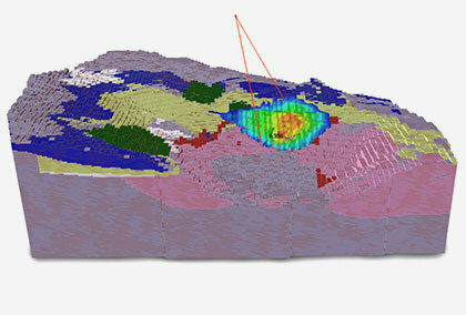
Current 3D slope stability modelling software now allows 3D wireframes (representing surveyed topography, geological surfaces, modelled faults, etc.) to be directly imported into 3D limit equilibrium and 3D finite element software. This allows geotechnical engineers to build and compute 3D models in an incredibly short time frame, calculating a 3D factor of safety (FS) or 3D strength reduction factor (SRF) for large open pits in less than a day.
The same 3D modelling software also allows for the direct importation of deformation data recorded by slope monitoring radar and satellite imagery. This interoperability between modelling software and monitoring data has provided geotechnical engineers with an invaluable method to back-analyze material properties, refine slope stability models, and determine suitable remediation actions to stabilize the identified deforming sections of the slope.
Radar Monitoring of Slopes
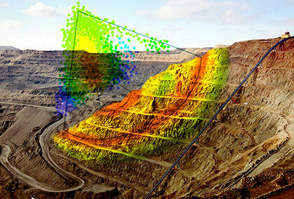
Synthetic aperture radar (SAR) monitoring is a tool used for both broad scale strategic monitoring and tactical-focus monitoring to determine progressive (accelerating) slope movement which can indicate impending slope failure.
SAR monitoring works by using a broad fan-beam to illuminate the same target multiple times within the same scan. For each pixel of a SAR image, a phase value is measured along the line-of-sight by the radar. By comparing phase differences of subsequent scans, it is possible to detect small variations that relate to sub-millimetre deformations of the slope.
This radar data can be easily imported into programs like Slide3 and RS3 and overlaid over models of predicted slope behaviour.
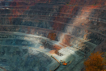
Case Study: Open Pit Gold Mine in Papua New Guinea
A case study was done recently demonstrating this integration of 3D limit equilibrium and 3D finite element modelling software with SAR monitoring data. In the case study, an open-pit gold mine in Papua New Guinea was modelled using Rocscience’s Slide3 and RS3 software.
The initial slope stability of the cutback was calculated to have an FS of approximately 1.49.
After several days of heavy rainfall though, slope deformation in the upper benches was identified by an IBIS-FM radar that was monitoring the +250 m high cutback.
Visual inspections on foot and remotely using an unmanned aerial vehicle (UAV) revealed the backscarp of the slope failure, where 20 to 50 cm wide cracks were observed at the crest of the failure zone. Further investigation established that the failure mechanism was related to a low-angle, in-pit dipping relic fault within the argillic-altered rock mass overlain by colluvium. Additionally, pore pressures recorded in a nearby vibrating wireline piezometer indicated that the slope was likely to be fully saturated.
In response to all of this, the slope stability models were subsequently updated with these new conditions, and a reduced FS of 1.03 and SRF of 0.92 was calculated.
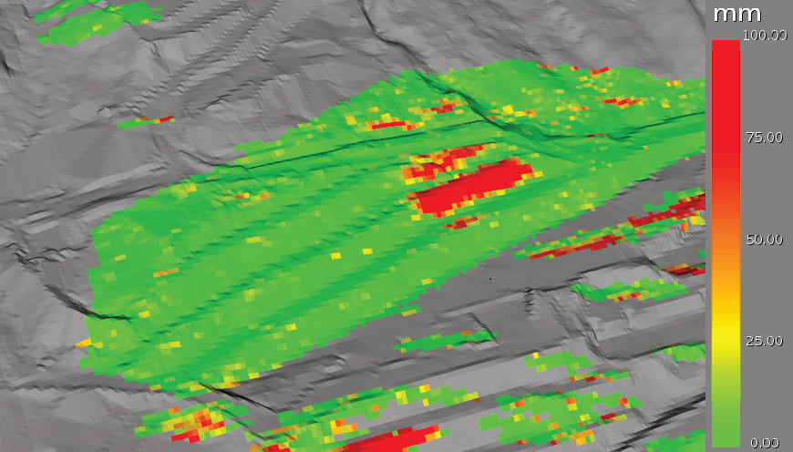
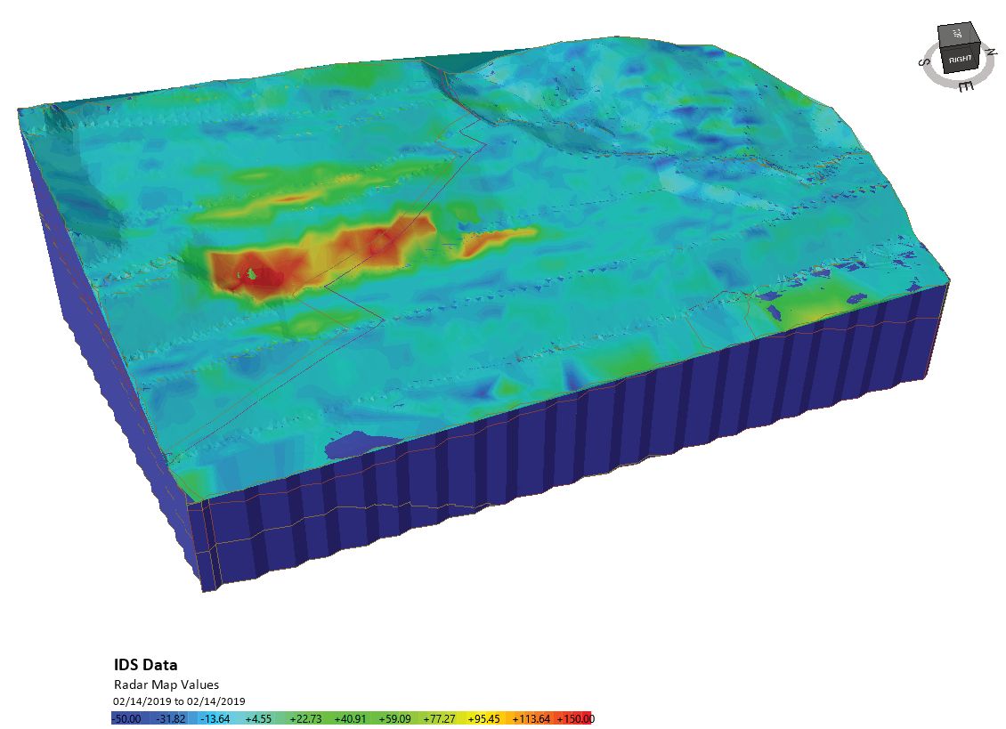
The monitoring data previously mentioned was superimposed on the 3D limit equilibrium analysis and 3D finite element analysis model results. As shown below, a good correlation was observed between the predicted slip surface locations and the actual slope movement shown in the recorded data.
After updating the model, remediation options were determined by running a series of additional slope stability models in the software that assessed various unloading, buttressing and depressurization options. Models simulating deep horizontal drains and unloading indicated the FS could be improved by 15–30% using these stabilization techniques.
Limit Equilibrium vs Finite Element Modelling
In the case study mentioned above, a combination of both limit equilibrium and finite element modelling are used for analyzing the slope.
Limit equilibrium modelling (used in Rocscience’s Slide3 program) is one of the most common methods of assessing slope stability, in both civil and mining applications. Its widespread application is attributed to its ease of use, relatively fast calculation time and calibration from years of application and observation. For slope designs with multiple weak structures and/or multiple material properties of varying strengths though, a finite element analysis can provide additional benefits.
Finite element models, like those created in RS3, can enhance the modelling process by allowing the geotechnical engineer to calculate stresses, displacements and pore pressures using a variety of linear and non-linear constitutive relationships. The results of finite element analysis, in particular the SRF calculated by this method, are frequently used to validate both the FS and critical slip surfaces calculated by limit equilibrium modelling.
In the mentioned cased study, the finite element analysis allowed for the analysis of both the stress and deformation of materials within the slope, as well as the distribution of pore pressure.
Read More
This article is a summary of the paper 3D slope stability modelling and its interoperability with interferometric radar data to improve geotechnical design by A. McQuillan et al. The paper was presented at the 2020 International Symposium on Slope Stability in Open Pit Mining and Civil Engineering on May 12, 2020. To read the full paper, click here.
Image Courtesy: IDS GeoRadar